2026.08.30 (일) 13:26




 다시 흔들리는 해남 지진 / 사진제공=ai호남뉴스 |
전남광주 해남에서 6년 만에 다시 수십 차례의 연속지진이 발생하면서 주민들의 불안이 커지고 있다.
특히 2020년 연속지진과 올해 지진이 모두 지하 약 20㎞의 좁은 지역에 집중되고 최대 규모 역시 3.1로 나타나면서, 해남 지하에서 어떤 단층 운동이 반복되고 있는지 장기적인 정밀조사가 필요하다는 지적이 나온다.
기상청과 행정안전부, 한국지질자원연구원(KIGAM)의 공식자료를 종합하면 이번 지진은 한반도 지각에 작용하는 응력이 지하 깊은 곳의 단층을 움직이면서 발생한 것으로 분석되고 있다.
다만 정부와 전문가들은 현재까지의 관측 결과를 토대로 대규모 지진으로 이어질 가능성은 낮은 것으로 판단하면서도 추가 지진에 대비한 감시와 조사는 계속해야 한다는 입장이다.
■ 언제·어디서 발생했나…8월14일부터 해남서 집중
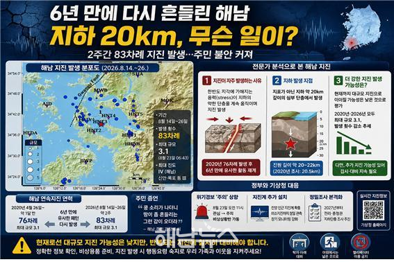
기상청에 따르면 해남지역에서는 지난 8월14일부터 26일 오후 5시까지 약 2주 동안 모두 83차례의 지진이 관측됐다.
가장 큰 지진은 지난 23일 오전 6시43분 발생한 규모 3.1 지진이다.
행정안전부가 23일까지 집계한 공식통계를 보면 당시까지 규모 2.0 이상 지진 7차례를 포함해 총 71차례의 소규모 지진이 발생했다.
규모 3.1 지진 당시 해남에서는 최대 계기진도 Ⅳ가 관측됐다. 목포·무안·신안·영암·진도에서는 진도 Ⅲ, 강진·광산·나주·완도·장흥·함평에서는 진도 Ⅱ가 기록됐다.
행안부에는 당시 해남과 신안에서 각각 1건씩 모두 2건의 유감신고가 접수됐지만 직접적인 시설 피해 신고는 없었다.
■ 얼마나 좁은 곳에서 발생했나…불과 500m×300m
이번 연속지진에서 특히 주목되는 것은 발생 범위가 매우 좁다는 점이다.
기상청이 26일 국내 지진 전문가들과 분석한 결과 2020년과 2026년 해남 지진은 모두 길이 약 500m, 폭 약 300m 범위의 작은 지하 영역에 집중됐다.
2020년 지진군과 올해 지진군은 약간 떨어져 형성돼 있으며, 두 지진 분포 사이에서 23일 규모 3.1 지진이 발생한 것으로 분석됐다.
이는 해남 전체가 광범위하게 흔들리고 있다는 의미라기보다 특정 지하 영역에서 단층 운동에 따른 지진에너지가 집중적으로 방출되고 있다는 의미에 가깝다
.
■ 왜 발생했나…지하 약 20㎞ 단층 운동 주목
행정안전부가 24일 기상청과 국립재난안전연구원, 한국지질자원연구원, 부산대, 한국전력공사 전력연구원 등과 개최한 전문가 회의에서는 이번 지진이 한반도 지각에 가해지는 응력에 따른 단층 운동의 결과로 분석됐다.
특히 지진들은 지표 가까이가 아닌 약 20㎞ 깊이의 하부 지각에서 발생하고 있는 것으로 파악됐다.
한국지질자원연구원이 2020년 해남 연속지진 당시 실시했던 정밀조사 결과도 이번 사태를 이해하는 중요한 자료다.
지질자원연은 당시 규모 3급 지진의 진원 깊이를 약 **20.5㎞**로 분석했다.
또 지진을 일으킨 단층은 서북서-동남동 방향의 심부 단층이며, 좌수향 주향이동 운동에 의해 지진이 발생한 것으로 판단했다.
이는 한반도에 작용하는 지체응력 환경과도 부합한다고 연구원은 설명했다.
■ 광주단층이 움직인 것인가…2020년 조사에선 “관련성 낮다”
해남 지진이 반복되면서 인근 대규모 단층과의 연관성도 관심사다.
그러나 한국지질자원연구원이 2020년 해남 지진을 조사한 결과에서는 당시 지진을 발생시킨 단층과 광주단층을 비롯한 북북동-남남서 방향의 대규모 단층대와의 관련성은 적은 것으로 평가됐다.
당시 연구진은 해남 지진이 서북서-동남동 방향의 중·소규모 단층계에 의해 발생한 것으로 판단하면서 이를 근거로 대형지진 발생 가능성을 낮게 평가했다.
다만 이는 2020년 조사 결과다.
따라서 2026년 연속지진까지 동일한 단층운동에 의해 발생했다고 단정하려면 올해 지진의 정밀 진원분포와 단층면 분석 등 추가 연구가 필요하다.
■ 2020년에도 76차례…6년 만에 되풀이
해남 주민들이 더욱 불안해하는 이유는 이번 연속지진이 처음이 아니기 때문이다.
기상청에 따르면 2020년 4월26일부터 약 한 달 반 동안 해남에서 총 76차례의 작은 지진이 발생했다.
당시 최대 규모 역시 3.1이었다.
올해도 8월14일부터 같은 지역에서 2020년과 유사한 형태의 지진활동이 시작됐고 23일 규모 3.1 지진이 발생했다.
결국 해남에서는
2020년 76차례 연속지진 → 최대 규모 3.1
에 이어 6년 만인
2026년 약 2주간 83차례 → 최대 규모 3.1
이라는 유사한 현상이 다시 나타난 셈이다.
■ 주민 “‘쿵’ 소리 나더니 땅이 흔들렸다”
계기상 규모는 크지 않았지만 진앙과 가까운 주민들이 느낀 충격은 달랐다.
AI호남뉴스가 확보한 방송 화면에서 해남 주민 김장배 씨는 지난 23일 지진 당시 상황에 대해 “쿵 소리가 나더니 땅이 좀 흔들리는 그런 감이 오더라”고 설명했다.
해남을 벗어난 신안에서도 흔들림을 느꼈다는 증언이 나왔다.
특히 2020년에도 같은 지역에서 연속지진을 경험했던 주민들에게는 6년 만에 비슷한 현상이 되풀이됐다는 점 자체가 불안감을 키우는 요인이 되고 있다.
■ 기상청 “규모 3.1 이후 응력 상당 부분 해소 가능성”
현재 기상청과 전문가들의 분석은 비교적 신중하지만 긍정적인 쪽에 무게가 실린다.
기상청이 26일 개최한 전문가 회의에는 부경대·부산대·전남대·서울대·강원대·연세대의 지진 전문가들이 참여했다.
전문가들은 2020년과 2026년 지진 분포 사이에서 23일 규모 3.1 지진이 발생하면서 대부분의 응력이 해소됐을 가능성이 있는 것으로 진단했다.
실제로 규모 3.1 지진 이후 지진 발생 횟수는 감소하는 경향을 나타냈다.
2020년에도 최대 규모 지진 이후 지진활동이 점차 저조해졌다는 점을 고려하면 올해 역시 비슷한 감소 추세를 보일 가능성이 있다는 것이다.
2013년 보령 해역에서는 159차례의 연속지진이 발생했고 최대 규모는 3.5였으며, 2019년 백령도에서도 102차례의 지진이 발생했지만 최대 규모는 2.7이었다.
이들 사례 역시 더 큰 지진으로 이어지지 않았다는 점도 전문가들의 판단 근거 가운데 하나다.
■ 행안부 “대규모 지진 가능성 낮지만 ‘주의’ 유지”
정부 역시 당장 대형지진 가능성을 높게 평가하고 있지는 않다.
행정안전부는 전문가 분석을 토대로 해남에서 대규모 지진이 발생할 가능성은 낮은 것으로 판단했다.
그러나 같은 지역에서 지진이 계속 반복된다는 점을 고려해 23일 오전 11시를 기해 지진 위기경보를 ‘관심’에서 ‘주의’ 단계로 상향하고 비상상황반을 가동했다.
또 실제 대규모 지진이 발생하는 상황을 가정해 관계기관 합동 도상훈련도 실시할 방침이다.
김용균 행정안전부 자연재난실장은 대규모 지진 발생 가능성이 높지는 않다는 전문가 분석에도 불구하고 관계기관에 당분간 비상 대비태세를 유지하고 상황관리에 만전을 기할 것을 주문했다.
■ 앞으로 무엇을 하나…진앙에 지진계 추가 설치
전문가들은 이번 사태가 감소 추세를 보이더라도 관측을 끝내서는 안 된다는 데 의견을 모았다.
특히 진앙 인근에 지진계를 추가 설치해 규모 2.0 미만의 미소지진까지 정밀하게 탐지하고 장기간 추가 지진활동을 관찰할 필요가 있다고 제안했다.
기상청은 현재 한반도에서 발생하는 미소지진을 정밀 탐지하고 지진을 일으키는 지하단층을 조사하기 위해 ‘지하단층 및 속도구조 통합모델 개발 연구사업’을 추진하고 있다.
전라·충청권에 대한 본격적인 조사 연구는 2027년부터 착수할 계획이다.
이미선 기상청장은 “365일 24시간 지진·지진해일·화산 감시 및 통보 체계를 가동하고 있다”며 해남지진을 비롯한 한반도와 주변국 지진감시에 최선을 다하겠다고 밝혔다.
■ ‘대지진 전조’ 단정은 경계…그러나 장기조사는 필요
현재까지 공개된 기상청·행정안전부·한국지질자원연구원의 분석을 종합하면 이번 연속지진을 대규모 지진의 전조라고 판단할 과학적 근거는 확인되지 않았다.
오히려 전문가들은 규모 3.1 지진 이후 응력이 상당 부분 해소됐을 가능성과 지진 발생 횟수 감소에 무게를 두고 있다.
그러나 해남에서 2020년 76차례에 이어 2026년 다시 80차례가 넘는 지진이 비슷한 좁은 지역에서 집중적으로 발생했다는 사실은 별개의 문제다.
특히 2020년 한국지질자원연구원의 조사에서 이미 지하 약 20.5㎞의 심부 단층 운동이 확인된 만큼, 올해 지진이 당시 단층과 어떤 구조적 관계를 갖는지 규명할 필요성이 커졌다.
정부와 지자체 역시 단순히 “큰 지진 가능성이 낮다”는 전망에 그칠 것이 아니라 진앙지역 정밀 단층조사와 지진계 확충, 공공시설 및 노후 건축물 내진성능 점검, 주민 대피시설과 행동요령 점검 등 실질적인 대비책을 병행해야 한다는 지적이다.
해남 땅속 약 20㎞에서 6년의 간격을 두고 되풀이되고 있는 연속지진의 원인을 과학적으로 규명하는 것이 주민 불안을 해소하고 향후 지진재난에 대비하기 위한 핵심 과제로 떠오르고 있다.
Haenam Shaken Again After Six Years… 83 Earthquakes in Two Weeks: What Is Happening 20 km Underground?
Series of earthquakes northwest of Haenam since Aug. 14… Magnitude 3.1 quake on Aug. 23, maximum intensity IV
Same area recorded 76 earthquakes in 2020… Maximum magnitude was also 3.1
KMA: “Earthquake frequency declining after M3.1 event… Much of the accumulated stress may have been released”
Interior Ministry raises earthquake alert to “Caution” and activates emergency response team… “Low likelihood of a major earthquake”
KIGAM’s 2020 investigation identified deep fault movement at 20.5 km… Link to Gwangju Fault considered unlikely
Resident: “There was a thud, then the ground shook”… Repeated tremors fuel anxiety
Additional seismic stations planned near epicentral area… Detailed fault survey of Jeolla and Chungcheong regions to begin in 2027
[Haenam=AI Honam News] aihnnews@kakao.com
HAENAM — Residents of Haenam in South Korea’s southwestern region are growing increasingly concerned after dozens of earthquakes struck the area in a concentrated sequence, six years after a similar swarm occurred in 2020.
Of particular concern is that both the 2020 and 2026 earthquake sequences were concentrated within a small area at a depth of roughly 20 kilometers, while the strongest earthquake in both cases had a magnitude of 3.1. The recurrence has raised calls for long-term, detailed investigations into the fault activity beneath Haenam.
According to official data and analyses from the Korea Meteorological Administration (KMA), the Ministry of the Interior and Safety, and the Korea Institute of Geoscience and Mineral Resources (KIGAM), the earthquakes are believed to have resulted from fault movement caused by tectonic stress within the Korean Peninsula.
Government agencies and earthquake experts currently assess the likelihood of the swarm developing into a major earthquake as low. However, they stress that continued monitoring and further geological investigation are necessary.
■ When and where did the earthquakes occur? — Activity concentrated in Haenam since Aug. 14
According to the KMA, 83 earthquakes were detected in the Haenam area between Aug. 14 and 5 p.m. on Aug. 26, a period of approximately two weeks.
The strongest occurred at 6:43 a.m. on Aug. 23, with a magnitude of 3.1.
According to official statistics compiled by the Ministry of the Interior and Safety through Aug. 23, 71 earthquakes had been detected by that point, including seven with magnitudes of 2.0 or greater.
The magnitude 3.1 earthquake produced a maximum instrumental intensity of IV in Haenam. Intensity III was recorded in Mokpo, Muan, Sinan, Yeongam and Jindo, while intensity II was recorded in Gangjin, Gwangsan, Naju, Wando, Jangheung and Hampyeong.
The Interior Ministry received two reports from people who felt the earthquake — one each in Haenam and Sinan — but no direct property or infrastructure damage was reported.
■ How concentrated was the activity? — Within an area of just 500 by 300 meters
One of the most notable characteristics of the earthquake sequence is the extremely limited area in which the tremors occurred.
An analysis conducted by the KMA and domestic earthquake experts on Aug. 26 found that the 2020 and 2026 Haenam earthquakes were concentrated within an underground zone measuring only about 500 meters long and 300 meters wide.
The 2020 and 2026 earthquake clusters were located slightly apart from one another, with the magnitude 3.1 earthquake on Aug. 23 occurring between the two clusters.
This suggests that the phenomenon is not a broad seismic disturbance affecting all of Haenam, but rather a concentrated release of seismic energy associated with fault movement within a relatively small underground area.
■ What caused the earthquakes? — Attention focused on fault movement about 20 km underground
On Aug. 24, the Ministry of the Interior and Safety convened an expert meeting involving the KMA, the National Disaster Management Research Institute, KIGAM, Pusan National University and the Korea Electric Power Corporation Research Institute.
Experts concluded that the earthquakes were associated with fault movement caused by tectonic stress acting on the crust beneath the Korean Peninsula.
The earthquakes were found to have occurred not near the surface, but in the lower crust at depths of around 20 kilometers.
The results of KIGAM’s detailed investigation into the 2020 Haenam earthquake swarm also provide important clues for understanding the latest activity.
KIGAM estimated the focal depth of the magnitude-3-class earthquakes in 2020 at approximately 20.5 kilometers.
The institute concluded that the earthquakes were generated along a deep fault trending west-northwest to east-southeast and involved left-lateral strike-slip movement.
Researchers said the mechanism was consistent with the broader tectonic stress environment affecting the Korean Peninsula.
■ Did the Gwangju Fault move? — 2020 investigation found little evidence of a connection
As earthquakes continue to recur in Haenam, attention has also focused on whether the activity may be related to major regional fault systems.
However, KIGAM’s investigation of the 2020 Haenam earthquakes concluded that the fault responsible for those events had little apparent connection with the Gwangju Fault or other major north-northeast–south-southwest-trending fault zones.
Researchers at the time concluded that the Haenam earthquakes were likely generated by a west-northwest–east-southeast-trending small- to medium-scale fault system. This was also one of the factors behind their assessment that the likelihood of a large earthquake was relatively low.
That conclusion, however, was based on the 2020 earthquake sequence.
Determining whether the 2026 earthquakes were generated by the same fault system will require further analysis of their precise hypocentral distribution and fault-plane geometry.
■ 76 earthquakes in 2020… A similar pattern returns six years later
Residents are particularly concerned because this is not the first earthquake swarm to affect Haenam.
According to the KMA, 76 small earthquakes occurred in Haenam over roughly six weeks beginning on April 26, 2020.
The largest earthquake at that time also had a magnitude of 3.1.
This year, similar seismic activity began in the same general area on Aug. 14, followed by another magnitude 3.1 earthquake on Aug. 23.
The pattern can therefore be summarized as:
2020: 76 earthquakes → Maximum magnitude 3.1
2026: 83 earthquakes in about two weeks → Maximum magnitude 3.1
The striking similarity between the two episodes has intensified calls for a clearer scientific explanation of the underground structure in the region.
■ Resident: “There was a thud, then the ground shook”
Although the recorded magnitudes were relatively small, residents living near the epicentral area described a much stronger sense of impact.
In broadcast footage obtained by AI Honam News, Haenam resident Kim Jang-bae recalled the Aug. 23 earthquake, saying:
“I heard a thud, and then I felt the ground shake a little.”
People in neighboring Sinan also reported feeling the tremor.
For residents who experienced the 2020 earthquake swarm, the recurrence of a similar phenomenon six years later has become a significant source of anxiety.
■ KMA: “Much of the stress may have been released after the magnitude 3.1 earthquake”
The KMA and earthquake experts remain cautious but have placed greater weight on indications that the activity may be subsiding.
The KMA convened an expert meeting on Aug. 26 involving earthquake specialists from Pukyong National University, Pusan National University, Chonnam National University, Seoul National University, Kangwon National University and Yonsei University.
Experts assessed that the magnitude 3.1 earthquake on Aug. 23, which occurred between the 2020 and 2026 earthquake clusters, may have released a significant portion of the accumulated tectonic stress.
The number of earthquakes has in fact shown a declining trend since the magnitude 3.1 event.
A similar pattern occurred in 2020, when seismic activity gradually declined after the strongest earthquake. Experts therefore believe this year’s sequence could follow a comparable pattern.
Previous earthquake swarms elsewhere in South Korea have shown similar characteristics.
In 2013, 159 earthquakes occurred in waters off Boryeong, with the largest reaching magnitude 3.5. In 2019, 102 earthquakes occurred near Baengnyeong Island, with a maximum magnitude of 2.7.
Neither sequence developed into a major earthquake, a factor experts have also considered in assessing the Haenam situation.
■ Interior Ministry: Major earthquake unlikely, but “Caution” alert remains in effect
The South Korean government also does not currently assess the risk of an imminent major earthquake as high.
Based on expert analysis, the Ministry of the Interior and Safety concluded that the likelihood of a major earthquake occurring in Haenam is low.
However, because earthquakes continued to occur in the same area, the ministry raised the earthquake crisis alert from “Attention” to “Caution” at 11 a.m. on Aug. 23 and activated an emergency response team.
Authorities also plan to conduct a joint tabletop exercise simulating a major earthquake involving relevant government agencies.
Kim Yong-kyun, head of the ministry’s Natural Disaster Management Office, instructed relevant agencies to maintain emergency preparedness and closely manage the situation despite expert assessments that the probability of a major earthquake remains low.
■ What happens next? — Additional seismic instruments to be installed near the epicenter
Experts agreed that monitoring should continue even if the current earthquake sequence appears to be declining.
They recommended installing additional seismic instruments near the epicentral area to detect microearthquakes below magnitude 2.0 and to monitor seismic activity over an extended period.
The KMA is currently conducting a research project aimed at developing an integrated model of underground faults and seismic velocity structures across the Korean Peninsula.
The project is intended to improve detection of microearthquakes and identify subsurface faults capable of generating earthquakes.
A full-scale investigation of underground fault structures in the Jeolla and Chungcheong regions is scheduled to begin in 2027.
KMA Administrator Lee Mi-sun said the agency operates a 24-hour, 365-day monitoring and notification system for earthquakes, tsunamis and volcanic activity, and will continue closely monitoring seismic activity in Haenam as well as across the Korean Peninsula and neighboring regions.
■ No scientific basis yet to call it a “precursor to a major earthquake” — but long-term investigation is needed
Based on currently available analyses from the KMA, the Interior Ministry and KIGAM, there is no confirmed scientific evidence that the Haenam earthquake swarm is a precursor to a major earthquake.
Experts instead point to the possibility that much of the accumulated stress was released by the magnitude 3.1 earthquake and note that the frequency of subsequent earthquakes has declined.
That does not, however, diminish the significance of what has occurred.
After 76 earthquakes in 2020, more than 80 earthquakes have again occurred in 2026 within a similarly small area beneath Haenam.
KIGAM’s 2020 investigation already identified deep fault movement at a depth of approximately 20.5 kilometers. Determining how the 2026 earthquake sequence is structurally related to that fault activity has therefore emerged as an important scientific task.
Beyond assurances that the probability of a major earthquake is currently low, the central and local governments may need to pursue practical preparedness measures, including detailed fault investigations around the epicentral area, expansion of seismic monitoring networks, seismic-resistance inspections of public facilities and older buildings, and reviews of evacuation facilities and earthquake safety procedures.
Scientifically determining why earthquake swarms have returned to the same area beneath Haenam after a six-year interval will be critical both to addressing residents’ concerns and to strengthening the region’s preparedness for future seismic disasters.
 해남뉴스 박충배 편집/논설 news@hbcnews.kr