2026.08.08 (토) 14:15




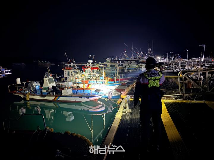 완도해경, 기상악화 대비 연안 안전사고 위험예보제 / 사진제공=완도해경 |
완도해양경찰서가 제13호 태풍 ‘돌핀’의 영향으로 높은 파도와 너울이 발생할 가능성이 커짐에 따라 연안사고 위험 예보제 ‘주의보’를 발령하고 해안가 취약지역에 대한 안전관리를 강화한다.
완도해경은 8월 7일부터 태풍에 따른 기상악화에 대비해 연안사고 위험예보를 ‘주의보’ 단계로 상향하고 방파제와 갯바위, 해수욕장 등 사고 위험이 높은 연안해역을 집중적으로 관리한다고 밝혔다.
이번 주의보는 태풍의 이동 경로와 강도가 유동적인 데다 주말 사이 전 해상에 기상특보가 발효될 가능성이 있고, 연안지역에는 너울을 동반한 높은 물결이 예상됨에 따라 인명피해를 선제적으로 예방하기 위해 발령됐다.
연안사고 위험예보제는 기상악화나 자연재난 등으로 연안해역에서 안전사고가 발생할 우려가 있을 때 국민에게 위험성을 미리 알리는 제도다. 위험 수준에 따라 ‘관심·주의보·경보’ 등 3단계로 운영된다.
완도해경은 주의보가 유지되는 동안 관할 파출소를 중심으로 방파제와 갯바위, 해수욕장 등 연안사고 취약지역에 대한 순찰을 강화한다.
특히 높은 파도와 너울에 휩쓸릴 위험이 있는 구역의 출입을 예방하고 어민과 관광객, 낚시객 등을 대상으로 기상악화 시 지켜야 할 연안 안전수칙을 집중적으로 홍보할 방침이다.
지자체를 비롯한 관계기관에도 위험예보 발령 사실을 신속하게 전파하고 전광판과 안내방송 등 가용 홍보매체를 활용해 기상정보와 연안 위험상황을 안내한다.
태풍의 직접적인 영향권에서 벗어나더라도 먼바다에서 발생한 너울성 파도가 해안가로 갑자기 밀려들 수 있어 각별한 주의가 필요하다. 기상특보가 내려진 상황에서는 방파제와 갯바위, 해안도로, 저지대 해안가 등에 접근하지 않아야 한다.
김태환 완도해양경찰서장은 “태풍의 영향으로 해안가에 갑작스러운 높은 파도와 너울이 발생할 수 있는 만큼 방파제와 갯바위 등 위험지역 출입을 자제해 달라”고 당부했다.
이어 “연안활동에 나서기 전 반드시 기상정보를 확인하고 현장 안전요원의 통제와 안내에 적극적으로 협조해 주길 바란다.”고 말했다.
태풍의 진로와 강도는 단시간에도 달라질 수 있다. 완도해경과 지자체는 단순한 주의 안내에 그치지 말고 기상특보 발효 전부터 위험구역 출입 통제와 계류선박 점검, 항·포구 안전관리 등을 선제적으로 강화해야 한다.
Wando Coast Guard Issues Coastal Accident Risk Advisory as Typhoon Dolphin Approaches
Coastal safety management strengthened from August 7 until weather conditions improve
High waves and swells expected under influence of Typhoon No. 13
Marine weather advisories may be issued across all seas over the weekend
Patrols intensified around breakwaters, rocky shores and beaches
Risk information shared with local governments and related agencies
Tourists and anglers urged to avoid hazardous areas and follow safety rules
“Check weather information before coastal activities and follow safety officers’ instructions”
Proactive access restrictions and vessel safety checks needed amid uncertainty over typhoon’s path
【Wando=Haenam News】 haenamnews@kakao.com
The Wando Coast Guard has issued a coastal accident risk advisory and strengthened safety management in vulnerable coastal areas as high waves and swells are expected under the influence of Typhoon No. 13, Dolphin.
The Coast Guard said it raised the coastal accident risk alert to the “advisory” level on August 7 in preparation for worsening weather conditions. It will closely monitor coastal waters and high-risk locations, including breakwaters, rocky shores and beaches.
The advisory was issued as the typhoon’s path and intensity remain uncertain. Marine weather advisories may be issued across all seas over the weekend, while high waves accompanied by swells are expected along coastal areas.
The measure is intended to prevent coastal accidents and casualties before hazardous conditions develop.
The coastal accident risk warning system is designed to notify the public in advance when worsening weather, natural disasters or other conditions may increase the risk of accidents in coastal waters. It operates at three levels: “Attention,” “Advisory” and “Warning.”
While the advisory remains in effect, the Wando Coast Guard will intensify patrols around areas vulnerable to coastal accidents, including breakwaters, rocky shores and beaches, with local coast guard stations taking the lead.
Authorities will work to prevent people from entering areas where they could be swept away by high waves or swells. Safety guidance for worsening weather will also be provided to fishermen, tourists and anglers.
The Coast Guard will promptly share information about the advisory with local governments and related agencies. Electronic signboards, public address systems and other available communication channels will be used to provide weather updates and warnings about coastal hazards.
Extra caution is required because swells generated far offshore can suddenly reach the coast even when an area is outside the typhoon’s direct impact zone. When marine weather advisories are in effect, people should stay away from breakwaters, rocky shores, coastal roads and low-lying waterfront areas.
“Sudden high waves and swells may strike coastal areas under the influence of the typhoon, so people should avoid entering hazardous locations such as breakwaters and rocky shores,” Wando Coast Guard Chief Kim Tae-hwan said.
“Before engaging in any coastal activity, please check the latest weather information and fully cooperate with the instructions and access restrictions issued by on-site safety personnel,” he added.
A typhoon’s path and intensity can change rapidly. The Wando Coast Guard and local governments must go beyond issuing safety reminders by proactively restricting access to hazardous areas, inspecting moored vessels and strengthening safety management at ports and fishing harbors before severe weather alerts take effect.
 해남뉴스 박충배 편집 및 논설위원 news@hbcnews.kr