| “사흘간 네 차례 흔들렸다”…해남 서북서쪽서 규모 2.0대 지진 연속 발생 8월 14일부터 16일까지 규모 2.1·2.5·2.2·2.4 지진 잇따라 해남뉴스 박충배 편집 및 논설위원 news@hbcnews.kr |
| 2026년 08월 17일(월) 11:11 |
 해남 지진 연속 발생 / 사진제공=AI호남뉴스 |
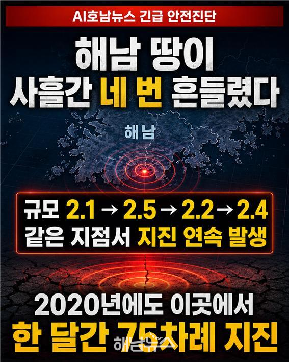
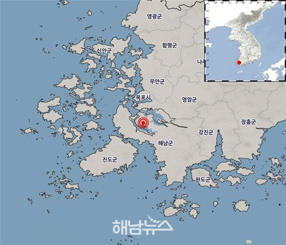
전남광주 해남군 서북서쪽 약 20~21㎞ 지역에서 사흘 동안 규모 2.0대 지진이 네 차례 연속 발생했다.
지진 규모는 크지 않고 현재까지 인명이나 시설물 피해도 확인되지 않았지만, 2020년 한 달여 동안 75차례의 지진이 집중적으로 발생했던 곳과 진앙 및 발생 깊이가 거의 일치해 관계 당국의 정밀 분석과 집중 관측이 필요하다는 지적이다.
기상청 국내지진 관측자료에 따르면 첫 번째 지진은 지난 14일 오후 5시 43분 38초께 해남군 서북서쪽 약 20~21㎞ 지역에서 발생했다. 규모는 2.1, 발생 깊이는 약 22㎞로 분석됐다.
이어 15일 오전 8시 31분 34초 같은 지역에서 규모 2.5의 지진이 발생했다. 진앙은 북위 34.66도, 동경 126.40도이며 발생 깊이는 22㎞였다.
16일에는 하루 동안 두 차례의 지진이 이어졌다.
이날 오전 9시 23분 44초 해남군 서북서쪽 21㎞ 지역에서 규모 2.2의 지진이 발생했다. 진앙은 북위 34.66도, 동경 126.40도이고 깊이는 21㎞로 분석됐다.
같은 날 오후 7시 34분 11초에는 해남군 서북서쪽 20㎞ 지역에서 규모 2.4의 지진이 또 발생했다. 진앙은 북위 34.66도, 동경 126.41도이며 깊이는 20㎞였다.
사흘 동안 발생한 네 차례 지진의 진앙 차이는 약 1㎞ 안팎에 불과하고, 발생 깊이도 20~22㎞로 비슷하다. 사실상 같은 지하 단층대에서 반복된 지진일 가능성이 제기되는 이유다.
네 차례 지진 모두 전남광주 지역에서 관측된 최대 계기진도는 Ⅱ였다.
진도 Ⅱ는 조용한 상태에 있거나 건물 위층에 있는 소수의 사람만 약한 흔들림을 느낄 수 있는 수준이다. 이번 지진과 관련해 현재까지 소방당국에 접수된 인명·시설물 피해 신고는 없는 것으로 파악됐다.
‘진도 2.0’ 아닌 ‘규모 2.0대’ 지진
이번 지진을 설명할 때 ‘진도 2.0 지진’이라는 표현은 정확하지 않다.
규모는 지진이 발생한 지점에서 방출된 에너지의 크기를 수치로 표시한 것이다. 이번 지진의 규모는 각각 2.1, 2.5, 2.2, 2.4다.
반면 진도는 특정 지역에서 사람이 느낀 흔들림이나 시설물에 미친 영향을 단계로 나타낸다. 이번 지진의 최대 계기진도는 로마숫자 Ⅱ다.
같은 지진이라도 진앙과의 거리, 지반 상태, 건축물의 높이와 구조 등에 따라 지역별 진도는 달라질 수 있다.
2020년 군발지진 발생지와 사실상 같은 곳
이번 지진이 주목되는 가장 큰 이유는 진앙이 2020년 해남 군발지진 발생지와 사실상 일치하기 때문이다.
기상청에 따르면 2020년 4월 26일부터 5월 31일까지 해남군 서북서쪽 약 21㎞ 지역에서 모두 75차례의 지진이 관측됐다. 당시 가장 큰 지진은 5월 3일 발생한 규모 3.1이었다.
당시 지진도 북위 34.66도, 동경 126.40도 부근과 지하 약 20㎞에 집중됐다. 이번 2026년 지진의 진앙과 깊이가 2020년 지진 발생 지점과 거의 같다.
기상청과 국내 지진 전문가들은 2020년 임시 지진관측망을 설치해 해당 지역을 정밀 분석했다.
분석 결과 지진의 진앙은 약 500m의 좁은 범위에 집중됐으며, 지하 20㎞ 부근에서 동남동-서북서 방향으로 분포한 것으로 확인됐다.
규모 2.0 이상 지진의 단층운동은 동남동-서북서 또는 북북동-남남서 방향의 주향이동 단층운동으로 분석됐다. 이는 한반도에서 일반적으로 나타날 수 있는 자연지진의 특성이라는 것이 당시 전문가들의 판단이었다.
대형 지진 전조로 단정할 근거 없어
2020년 전문가 회의에서는 해남에서 발생한 연속 지진을 대규모 지진의 전조로 보는 것은 성급하다는 의견이 제시됐다.
진앙이 좁은 범위에 집중돼 추정되는 단층의 크기가 크지 않고, 지진이 지하 약 20㎞의 비교적 깊은 곳에서 발생해 지표까지 전달되는 에너지가 상당 부분 감쇠한다는 점이 판단 근거였다.
2013년 보령 해역과 2019년 백령도 주변에서도 유사한 연속 지진이 발생했지만 대규모 지진으로 이어지지 않았다는 사례도 제시됐다.
이번 지진 역시 규모 2.1~2.5로 비교적 작고 발생 깊이가 20~22㎞에 이른다. 현재 관측 결과만 놓고 대형 지진의 전조라고 판단할 과학적 근거는 확인되지 않았다.
 해남지진 발생 위치도 / 사진제공=기상청 |
그러나 이번 지진을 2020년 군발지진과 동일한 원인으로 단정하는 것도 이르다.
진앙과 깊이가 거의 일치한다는 점에서 당시 활동했던 지하 단층대가 다시 움직였을 가능성은 제기할 수 있지만, 정확한 판단을 위해서는 지진파와 단층면, 규모 2.0 미만 미소지진의 분포를 종합적으로 분석해야 한다.
미소지진 포함한 정밀자료 공개해야
규모 2.0 이상 지진만으로 전체 상황을 판단해서는 안 된다는 지적도 나온다. 지진관측 장비에는 사람이 느끼지 못하는 규모 2.0 미만의 미소지진도 기록되기 때문이다.
2020년에도 기상청이 공식 집계한 지진은 75차례였지만, 연구자들이 미세한 지진파를 별도로 분석한 결과 수백 차례의 미소지진 신호가 확인될 수 있다는 분석이 나온 바 있다.
따라서 기상청과 해남군은 이번 지진 발생지역의 규모 2.0 미만 지진까지 면밀히 살펴 군발성 지진이 다시 시작된 것인지 확인할 필요가 있다.
특히 ▲미소지진을 포함한 실제 발생 횟수 ▲2020년 지진과 파형·진앙·단층면이 일치하는지 ▲임시 지진관측망 설치 필요성 ▲진앙 주변 주요 시설의 안전 상태 ▲추가 지진 발생 시 주민 안내체계 등을 점검해야 한다.
진앙 인근에는 주민 거주지역뿐만 아니라 솔라시도 개발지구와 산업·에너지 관련 시설 등이 있어 지속적인 지진 감시와 시설별 내진대책 점검도 요구된다.
‘피해 없음’ 발표만으로는 주민 불안 해소 어려워
규모 2.0대 지진은 통상 큰 피해를 일으킬 가능성이 낮다. 하지만 같은 지역에서 짧은 기간 반복되고 있고, 과거에도 대규모 군발지진이 발생했다는 점에서 주민들이 느끼는 불안은 가볍게 볼 수 없다.
해남군은 단순히 “피해 신고가 없다”는 발표에 그치지 말고 기상청과 협력해 지진 발생 현황과 과거 지진과의 연관성, 향후 관측계획을 주민에게 신속하고 투명하게 공개해야 한다.
주민들도 흔들림을 느끼면 튼튼한 탁자 아래에서 머리와 몸을 보호하고, 진동이 멈춘 뒤 가스와 전기를 확인해야 한다. 건물 밖으로 이동할 때는 엘리베이터 대신 계단을 이용하고, 유리창·간판·담장 등 낙하 위험이 있는 시설물과 거리를 둬야 한다.
현재 단계에서 공포를 키울 필요는 없지만, 지진은 정확한 발생 시각과 규모를 사전에 예측하기 어렵다. 관계 당국의 지속적인 정밀 관측과 신속한 정보공개, 주민 행동요령 안내가 필요한 시점이다.
“Four Tremors in Three Days”…Series of Magnitude 2.0-Level Earthquakes Strikes Northwest of Haenam
Magnitude 2.1, 2.5, 2.2 and 2.4 earthquakes recorded from August 14 to 16
Epicenters concentrated near 34.66°N, 126.40°E at depths of 20–22 kilometers
All four earthquakes registered a maximum instrumental intensity of II, with no casualties or property damage reported
Seventy earthquakes, including a magnitude 3.1 event, occurred in the same area over about a month in 2020
KMA said at the time that the quakes were concentrated in a narrow area at a depth of around 20 kilometers and were unlikely to be precursors to a major earthquake
Coordinates and depths of the 2026 earthquakes nearly match the 2020 swarm, requiring analysis of possible reactivation of the same fault
“Not intensity 2.0, but magnitude 2.0-level earthquakes—the maximum seismic intensity was II”
Haenam County urged to disclose microearthquake data and any connection to the 2020 earthquake swarm
【HAENAM=AI Honam News】 aihnnews@kakao.com
Four earthquakes in the magnitude 2.0 range struck an area approximately 20 to 21 kilometers west-northwest of Haenam County, Jeonnam-Gwangju, over three consecutive days.
Although the earthquakes were relatively small and no casualties or property damage have been reported, their epicenters and focal depths nearly coincide with those of 75 earthquakes that were concentrated in the same area over about a month in 2020. The recurrence has prompted calls for a detailed investigation and intensified monitoring by the relevant authorities.
According to the Korea Meteorological Administration’s domestic earthquake monitoring data, the first earthquake occurred at approximately 5:43:38 p.m. on August 14, about 20 to 21 kilometers west-northwest of Haenam County. It had a magnitude of 2.1 and an estimated focal depth of approximately 22 kilometers.
A magnitude 2.5 earthquake then occurred in the same area at 8:31:34 a.m. on August 15. Its epicenter was located at 34.66 degrees north latitude and 126.40 degrees east longitude, with a focal depth of 22 kilometers.
Two more earthquakes followed on August 16.
At 9:23:44 a.m., a magnitude 2.2 earthquake struck 21 kilometers west-northwest of Haenam County. Its epicenter was located at 34.66 degrees north latitude and 126.40 degrees east longitude, at a depth of 21 kilometers.
Later that day, at 7:34:11 p.m., another magnitude 2.4 earthquake occurred 20 kilometers west-northwest of Haenam County. Its epicenter was located at 34.66 degrees north latitude and 126.41 degrees east longitude, with a focal depth of 20 kilometers.
The epicenters of the four earthquakes were within approximately one kilometer of each other, while their focal depths ranged from 20 to 22 kilometers. This raises the possibility that the earthquakes occurred repeatedly along the same underground fault zone.
All four earthquakes registered a maximum instrumental intensity of II in the Jeonnam-Gwangju region.
Intensity II means that weak shaking may be felt by a small number of people who are at rest or on the upper floors of buildings. No reports of casualties or damage to facilities have been received by fire authorities in connection with the earthquakes.
Not “Intensity 2.0,” but Magnitude 2.0-Level Earthquakes
It is technically incorrect to describe the latest events as “intensity 2.0 earthquakes.”
Magnitude represents the amount of energy released at the source of an earthquake. The four earthquakes had magnitudes of 2.1, 2.5, 2.2 and 2.4, respectively.
Seismic intensity, by contrast, indicates the degree of shaking felt at a particular location and its effects on people, buildings and other structures. The maximum instrumental intensity recorded for these earthquakes was II, expressed as a Roman numeral.
Even during the same earthquake, seismic intensity can vary depending on the distance from the epicenter, local ground conditions and the height and structural characteristics of buildings.
Virtually the Same Location as the 2020 Earthquake Swarm
The most notable aspect of the latest earthquakes is that their epicenters virtually coincide with the site of the 2020 Haenam earthquake swarm.
According to the KMA, a total of 75 earthquakes were recorded approximately 21 kilometers west-northwest of Haenam County between April 26 and May 31, 2020. The strongest was a magnitude 3.1 earthquake that occurred on May 3.
Those earthquakes were also concentrated near 34.66 degrees north latitude and 126.40 degrees east longitude, at depths of around 20 kilometers. The epicenters and focal depths of the 2026 earthquakes are therefore nearly identical to those of the 2020 events.
The KMA and domestic earthquake experts installed a temporary seismic observation network in 2020 and conducted a detailed investigation of the area.
Their analysis found that the epicenters were concentrated within a narrow area approximately 500 meters across. The earthquakes were distributed along an east-southeast to west-northwest direction at depths of around 20 kilometers.
Fault-motion analyses of earthquakes with magnitudes of 2.0 or greater indicated strike-slip faulting in either an east-southeast–west-northwest or north-northeast–south-southwest direction. Experts said at the time that this was consistent with the characteristics of natural earthquakes commonly observed on the Korean Peninsula.
No Basis Yet to Conclude They Are Precursors to a Major Earthquake
At a 2020 meeting of earthquake experts, participants concluded that it would be premature to regard the series of Haenam earthquakes as precursors to a major earthquake.
Their assessment was based on the concentration of the epicenters within a narrow area, which suggested that the fault itself was not extensive, and on the relatively great focal depth of approximately 20 kilometers. Seismic energy tends to dissipate significantly before reaching the surface when an earthquake occurs at such a depth.
Similar earthquake sequences occurred in waters off Boryeong in 2013 and around Baengnyeong Island in 2019, but neither developed into a major earthquake. Those cases were also cited in support of the assessment.
The latest earthquakes were also relatively small, ranging from magnitude 2.1 to 2.5, and occurred at depths of 20 to 22 kilometers. Based on the observations currently available, no scientific evidence has been found to indicate that they are precursors to a major earthquake.
It would, however, also be premature to conclude that the 2026 earthquakes were caused by exactly the same mechanism as the 2020 swarm.
The nearly identical epicenters and depths raise the possibility that the underground fault zone active in 2020 has moved again. A reliable conclusion, however, will require a comprehensive analysis of seismic waveforms, fault-plane solutions and the distribution of microearthquakes below magnitude 2.0.
Detailed Data, Including Microearthquakes, Should Be Disclosed
Observers have also cautioned that the overall situation should not be assessed solely on the basis of earthquakes with magnitudes of 2.0 or greater. Seismic instruments can detect microearthquakes below magnitude 2.0 that are generally too weak to be felt by people.
In 2020, the KMA officially recorded 75 earthquakes in the area. Researchers noted, however, that separate analyses of extremely weak seismic signals could detect hundreds of microearthquakes.
The KMA and Haenam County should therefore closely examine earthquakes below magnitude 2.0 in the latest affected area to determine whether a new earthquake swarm has begun.
Authorities should particularly examine and disclose the following:
▲ The actual number of earthquakes, including microearthquakes
▲ Whether the waveforms, epicenters and fault-plane solutions match those of the 2020 earthquakes
▲ Whether a temporary seismic observation network should be installed
▲ The safety conditions of major facilities near the epicenters
▲ The public notification system to be used in the event of additional earthquakes
In addition to residential communities, the area near the epicenters includes the Solaseado development district and industrial and energy-related facilities. This makes sustained seismic monitoring and a review of earthquake-resistant safety measures at individual facilities particularly important.
Statements of “No Damage” Alone Cannot Ease Public Concern
Magnitude 2.0-level earthquakes are generally unlikely to cause significant damage. However, residents’ concerns should not be dismissed, given that the earthquakes occurred repeatedly in the same area over a short period and that a substantial earthquake swarm previously affected the area.
Haenam County should not limit its response to announcing that no damage has been reported. In cooperation with the KMA, it should promptly and transparently disclose information about the latest earthquakes, their possible connection to the 2020 events and future monitoring plans.
If residents feel shaking, they should protect their heads and bodies under sturdy tables. Once the shaking stops, they should check gas and electrical systems. When leaving a building, they should use stairs rather than elevators and keep away from windows, signboards, walls and other structures that may fall.
There is no need to create public fear at this stage. Earthquakes, however, cannot be predicted precisely in terms of timing or magnitude. Continued monitoring, prompt disclosure of information and clear guidance on appropriate public safety measures are therefore essential.
 해남뉴스 박충배 편집 및 논설위원 news@hbcnews.kr